• Skip to main content
  • Skip to primary sidebar
  • Skip to footer

Hiking around Flathead Lake

Welcome to Montana

  • Places to Hike
  • Places to Camp
  • Trailheads
  • Get Social

trail heads

Mission Mountains Wilderness

October 20, 2021 by Mike

Mission Mountains Wilderness
Located in the Flathead National Forest in Montana. 

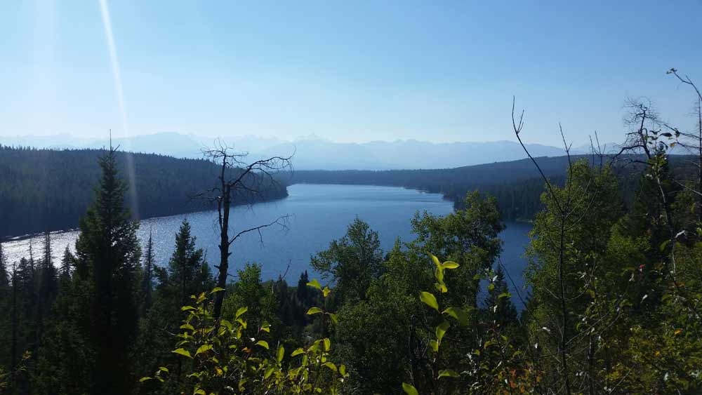
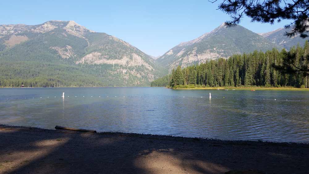
The Mission Mountains Wilderness is on the Swan Lake Ranger District of the Flathead National Forest in northwestern Montana. The Forest Service manages it as part of the National Forest System. Officially classified as Wilderness on January 4, 1975, the 73,877 acre area is managed in accordance with the Wilderness Act of 1964.  The Mission Mountains run along the east shore of Montana’s Flathead Lake.

The Mission Mountains, Holland LakeWhen to Visit – Most people visit the wilderness between July 1 and October 1. Snow-filled passes and high streams make earlier travel difficult and hazardous. High lakes do not open up until early or mid-June.

June is normally a wet month. Snow still covers high, shaded basins and surrounds trees.

July, August, and early September are dry months. Daytime temperatures are the 80-90 degree range. Showers are frequent. Nights are very cool. Snow occur at any time. Heavy snow generally occurs in late October and early November.

Mission Mountains Trail HeadIf you are a skier or winter camper, late February through May provide the best snow conditions and longer days. When planning an extended backcountry trip, be informed of potential avalanche conditions.

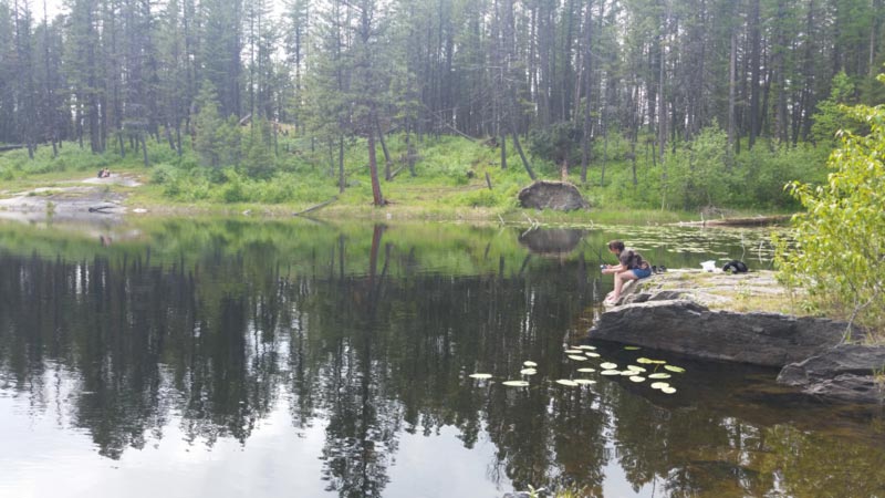
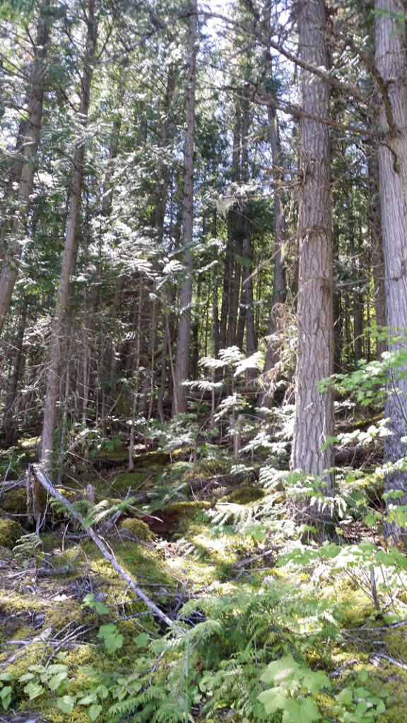
Trails – There are about 45 miles of maintained Forest Service system trails in the Mission Mountains. Most trails are better suited to hiking than horseback riding because of rugged terrain.

Travel is primarily by foot with some horseback use. Mountain bikes, hang gliders, motorized trail bikes, motorcycles, three and four wheelers, and snowmobiles are not permitted. Few of the trails can be called easy. Some are especially difficult because of steepness. You should be an experienced hiker to travel cross country and should possess map reading and compass skills.

Throughout the Mission Mountains you will find old Indian and packer trails. These are usually steep and difficult to follow. They are suitable for only the most experienced horse users or backpackers.

Mission Mountain TrailAccess Points – The major access points into the Mission Mountains Wilderness from the Swan Valley: Glacier Creek, Cold Lakes, Piper Creek, Fatty Creek, and Beaver Creek. Other access points from the Swan Valley include Lindbergh Lake (south end trail reached by boat), Jim Lakes, Hemlock Creek, Meadow Lake, and Elk Point.

There are also three major access points from the Salish & Kootenai Indian Reservation side of the Mission Mountains. Access through tribal lands requires a permit. These permits may be purchased at major sporting goods stores in Missoula and the Mission Valley or through the Confederated Salish and Kootenai Tribal Recreation Department in Pablo, Montana, phone (406) 675-2700.

A major portion of the Mission Mountains is suitable for backpacking only. Travel is strenuous, but it has many advantages: independence and self-sufficiency, opportunities for solitude, and you’re more carefree when backpacking.

DAY HIKES: The Mission Mountains has several hikes ranging from 1 1/4 miles to 6 miles (one way) which can be completed in a day. You will carry less on your back and travel more easily.

BACKPACKING: Backpacking requires careful planning. Proper equipment, with maximum utility and minimum weight, will make the trip easier. The most important items will be your pack, sleeping bag, and foot gear. Take only what you need. A pack that is too heavy can spoil your trip. A pack without adequate food, clothing and shelter can be equally disappointing and unpleasant.

The Go Hike With Mike trail guide contains most every trailhead along the Swan front of the Mission Mountains.

Filed Under: Hiking, Mission Mountain Wilderness, Mountain Top Views, Tourism, Trail Heads Tagged With: hiking, tourism, trail heads

ESTES LAKE TRAIL #96

May 25, 2021 by Mike

The Estes Lake trail is 1.5 miles long. It begins at the junction with Road #498 and ends at Estes Lake.

The trail starts out climbing slightly, goes over a knoll, and then descends, winding through the topography and between small wetlands; there is a small cedar grove near the lake. Estes Lake is a tannic lake bordered by lily pads and scattered with blue dragon flies (depending on the time of year).

The trail is open for Off Highway Vehicles (OHV) less than or equal to 50 inches wide, 2 wheeled vehicles, mountain biking, horseback riding, and hiking.

Estes Lake trail directions, from Bigfork, go south on Highway 35 for 0.7 miles, turning left onto Hwy 209. Stay on 209 for 3 miles, turning right at the light onto South Ferndale Rd. After 2 miles, merge right.

Estes Lake trail

Mike has been up and down this trail many times.  It is a favorite for out of area friends and guests.  If you want to make it interesting you can begin the trail down and it breaks off to many different points.  The beauty is it is really hard to get lost.  If you Hike down you end at Flathead Lake, or Crane Mountain.  In either case civilization is just around the corner.

If you are hiking somewhere other then around Montana’s Flathead Lake be sure to check out the Top 100 Hiking Blogs from Feed Spot.

Filed Under: Bigfork, Places to Hike, Trail Heads Tagged With: Bigfork, hiking, Swan Front, trail heads

Holland Lake Campground

March 4, 2021 by Mike

Holland LakeThe Holland Lake Campground is located seven miles south of Condon, Montana and 20 miles north of Seeley Lake, Montana off Montana Highway 83. From Highway 83 turn east on the Holland Lake Road and travel three and 1/2 miles east to the Y-intersection with the Owl Creek Loop Road. Follow Holland Lake Road to the left and the entrances to the group site and campground are a short distance down the road.

Restrictions: 16 day stay limit. Food storage required for human and stock food, garbage, and other attractants.  |  Closest Towns: Condon, MT – 9 miles.

Potable Water is available.  Restroom includes a flush toilet as well as a vault toilet

Passes: $30 season pass for day use is available through the concessionaire. This pass can be used at all campgrounds with day use fees on the Flathead National Forest under concession contract.  This campground is operated by Flathead Valley Campgrounds, Barta Enterprises, 406-646-1012

 Directions: From Highway 83 turn east onto Holland Lake Road #44 near mile marker 35. Follow this road about 3 miles. There are two loops, first the Bay Loop then the Larch Loop. The Campground host is located in the Larch Loop.

Activities include cabins and campground camping. There are 40 campsites, 50 foot maximum trailer length.

Holland Lake Trail Video

Filed Under: Holland Lake, Mountain Top Views, Places to Camp, Places to Hike, Trail Heads Tagged With: camping, hiking, trail heads

Murray Bay Campground

March 4, 2021 by Mike

Murray Bay CampgroundMurray Bay Campground is located high in the Rocky Mountains, less than 30 miles from the Continental Divide, surrounded by towering mountain peaks. Visitors can expect a variety of recreational activities, including, fishing, boating, swimming, hiking, exploring and big game hunting. The campground is 22 miles south of Martin City on the east shore of Hungry Horse Reservoir. This campground has a 16 day stay limit. Pets must be on a leash at all times while visiting campgrounds.

Murray Bay Campground

Reservations: This site can be reserved by calling Toll Free 1-877-444-6777 (International 518-885-3639 or TDD 877-833-6777 or on-line at www.recreation.gov .

Fees: Single Site $16 Double Site $32 Extra Vehicle $5 Day Use $5

The Go Hike with Mike trail guide contains most every trail head in the Flathead and Kootenai Forest as well as the Mission Mountain Tribal Wilderness, including this campground.  Click here to purchase your copy.

Boating is popular on the 27,750-acre reservoir. There is a concrete boat ramp accessible from within the campground. Swimming and fishing are also popular pastimes. Anglers can expect to catch a variety of fish, including cutthroat trout.

The hosted campground offers 20 overnight sites for tent and RV camping.  Campground roads and parking spurs are gravel. An on-site host is available to answer any questions about the campground and surrounding area.

Filed Under: Hungry Horse, Mountain Top Views, Places to Camp, Trail Heads Tagged With: hiking, Hungry Horse, trail heads

Emery Bay Campground

January 12, 2021 by Mike

Camping And Hiking at Emery Bay Campground

You just cant hike if you don’t have a place to lay your head. A popular campground in the Hungry Horse Ranger District is the Emery Bay Campground.

The Emery Bay Campground is located on the east shore of the Hungry Horse Reservoir off of Road 38.

You will enjoy a variety of recreational activities, including fishing, boating, swimming, hiking, and of course exploring.

Emery Bay Campground

The campground is situated along the massive Hungry Horse Reservoir, which was dammed to provide hydroelectric power and flood control to the area. It is the 10th highest dam in the United States and provides a stunning backdrop.

Boating is popular on the 27,750-acre reservoir, and a native boat ramp for smaller watercraft is available. Swimming and fishing are also popular pastimes, and anglers can expect a catch of cutthroat trout and other varieties.

A number of biking and hiking trails begin near the campground and wind around the surrounding landscape and shoreline.

Emery Bay Campground

The campground offers more than two dozen first-come, first-served campsites, available for tent and RV camping. A group campsite is also available and can accommodate up to 150 guests on two separate loops.

Each campsite includes tables and campfire rings with grills. As well as vault toilets and drinking water. An on-site host is available to answer any questions about the campground and surrounding areas.

Emery Bay Campground is just 15 miles southwest of the West Glacier entrance into Glacier National Park.

Filed Under: Hungry Horse, Mountain Top Views, Places to Camp, Trail Heads Tagged With: hiking, Hungry Horse, trail heads

Hiking around Hungry Horse

November 2, 2020 by Mike

When hiking around Hungry Horse you are in a Ranger District that is located near the western boundary of Glacier National Park and northeast of Flathead Lake. Get driving directions here.

The Hungry Horse Ranger District contains the Hungry Horse Dam and Reservoir – a popular recreation site and important nesting habitat for bald eagles.

Hiking around Hungry Horse

The district also contains a portion of the Jewel Basin Hiking Area, the Middle and South Forks of the Flathead River, and the Great Bear Wilderness.

Baby Moose on the trail.

Hungry Horse Ranger Station is located 22 miles northeast of Kalispell, MT and 10 miles south of Glacier National Park. The telephone number is 406-387-3800 and they are located at 10 Hungry Horse Drive,  Hungry Horse, MT 59919.

A popular campground near Hungry Horse Reservoir is Murray Bay Campground. It is located high in the Rocky Mountains. Less than 30 miles from the Continental Divide, surrounded by towering mountain peaks. Visitors can expect a variety of recreational activities, including, fishing, boating, swimming, hiking, exploring and big game hunting. The campground is 22 miles south of Martin City on the east shore of Hungry Horse Reservoir. This campground has a 16 day stay limit. Please leash your pets at all times when visiting.


Filed Under: Hungry Horse, Places to Hike Tagged With: hiking, Hungry Horse, trail heads

Phillips Trail #373

July 9, 2020 by Mike

Hike Flathead Lake
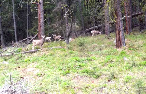
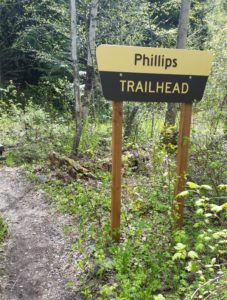
Hike Flathead Lake on Phillips Trail #373. Phillips Trail #373 is 3.8 miles long and climbs about 600 feet; it intersects with Crane Mtn Road #498 and the Beardance Trail #76. This is one of three trails that climb up Crane Mountain. Access by car from Crane Mountain is available 4/1-11/30, otherwise hikers must access from the Flathead Lake side at the Beardance trailhead (4.4 miles up). The trail is open for the following uses: hiking, horseback riding, and mountain biking.

Hike Flathead Lake

Usage: Light
Closest Towns: Bigfork
Directions:
Crane Mtn Access: From Bigfork go south on Highway 35 for 0.7 miles, turning left onto Hwy 209. Stay on 209 for 3 miles, then turn right at the light onto South Ferndale Rd. After 2 miles merge right onto Crane Mountain Rd also called Forest Service Road #498. The trail is 3 miles up on the west side of the road.

Flathead Lake Access: From Bigfork follow Highway 35 south, past Woods Bay, to the Beardance Picnic Area south of mile marker 23. The trailhead is on the east side of the highway, across from the parking lot.  If you are planning on vacationing around Flathead Lake, consider Mike’s Flathead Lake Vacation Guide.

Length : 3.8 miles
Elevation : 3,440 feet – 4,039 feet

Filed Under: Bigfork, Places to Hike, Trail Heads Tagged With: Bigfork, flathead lake, hiking, Swan Front, trail heads

Flathead Lake Trail #77

July 9, 2020 by Mike

Flathead Lake Trail
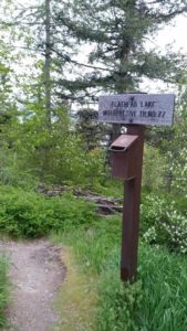
This short, family friendly 0.4 mile loop interpretive Flathead Lake trail. The short but steep distance down to excellent view of Flathead Lake and the western skyline. This trail was developed in partnership with the Bigfork High School.

If you have the opportunity to visit this trail during the month of May the may Flowers will be in full bloom.  The trail is a little steep going down.  However, it is very manageable for young and old alike.  The view from this Flathead Lake trail is exceptional.  At points on the trail you will see north into Woods Bay as well as east to Wildhorse Island.  Once at the bottom of this short trail be sure to refresh yourself with a plunge into the blue waters of Flathead Lake.

At a Glance
Usage: Light
Closest Towns: Bigfork
Water: No
Directions: To get to this trail head from Bigfork, go south on Highway 35 past Woods Bay, and turn right after mile marker 23, entering the Beardance trailhead parking. The trail goes downhill from both parking areas, creating a loop.

Location

Latitude : 47.95622819
Longitude : -114.0329612

Elevation : 3,071 feet – 3,071 feet

There is no camping at this trail head.  Camping is available in Wayfarers State Park about 10 miles to the north in Bigfork.

Filed Under: Bigfork, Places to Hike, Trail Heads Tagged With: Bigfork, flathead lake, hiking, Swan Front, trail heads

  • Go to page 1
  • Go to page 2
  • Go to Next Page »

Primary Sidebar

Hiking Around Flathead Lake

  • Bigfork
  • Cabinet Mountains
  • Flathead
  • Flathead Lake
  • Flathead River
  • Gear
  • Hiking
  • Holland Lake
  • Hungry Horse
  • Mission Mountain Wilderness
  • Mountain Top Views
  • Permits
  • Places to Camp
  • Places to Hike
  • Swan Front Trails
  • Tourism
  • Trail Heads
  • Trails
  • Videos
  • Yellow Bay

Purchase Your Copy

GoHikeWithMike Trail Guide.

Trailheads

Go Hike With Mike

Permits

Recreation Permits

Equipment

Hiking Equipment

Looking for the Vacation Guide?

Montana's Flathead Lake Vacation Guide

Purchase the Flathead Lake Vacation Guide

Footer

On The Trail:

Go Hike With Mike Website: GoHike WithMike.com

Go Hike With Mike Email: trails@gohikewithmike.com

Go Hike With Mike Social: #GoHikeWithMike

Hiking on Flathead Lake

Bigfork camping family fun flathead flathead lake flathead river gear Glacier National Park go hike with mike hiking Hungry Horse mission mountains montana pablo permits refuge Swan Front tourism trail guide trail heads trails video videos wildlife yellow bay

Flathead Lake Trail Guide

The Go Hike with Mike trail guide contains most every trail head in the Flathead and Kootenai Forest as well as the Mission Mountain Tribal Wilderness.  Click here to purchase your copy.

  • Camping Around Flathead Lake
  • Flathead Lake Trails and Camping
  • The Go Hike With Mike Trail Guide

Go Hike with Mike

Go Hike With Mike Website: GoHike WithMike.com
Go Hike With Mike Email: trails@gohikewithmike.com
Go Hike With Mike Social: #GoHikeWithMike